Field logbook and mapping tool for metal detectorists and relic hunters
dtecto records search routes with GPS mapping and stores photographic find records in a searchable library, helping detectorists track field work and research sites. Developed by Dtecto for Android, the app combines on-device AI identification, a community feed for sharing discoveries, and a daily conditions dashboard. Weekend hobbyists, relic hunters, and history-minded users gain practical tools for planning hunts, documenting finds, and reviewing past searches in one mobile workflow.
Maps and hunt tracking keep you oriented on the ground
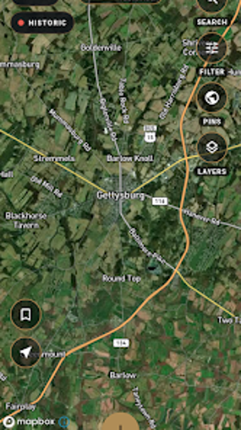
GPS Hunt Tracking logs routes in real time so you can confirm ground coverage and revisit locations. The app overlays recorded hunts on maps and offers a "Know Before You Go" dashboard that reports daily detecting conditions. These elements support planning and follow-up: you see past tracks, a weather snapshot, and whether you covered a given field during a session.
Research-grade mapping reaches beyond ordinary maps
The app provides LiDAR terrain overlays and historical map layers as advanced mapping modes, which help reveal buried structures and old road lines beneath vegetation in satellite imagery. Those overlays are described as part of a Pro tier, so users who need high-resolution terrain detail can enable the LiDAR and USGS historical map layers for targeted site research before a hunt.
Field logging, AI ID, and community features fit daily workflows
The digital find library stores photos, GPS coordinates, categories, and notes for each discovery, while on-device AI offers instant identification and an estimated era with a confidence score. A community feed connects detectorists for sharing and commentary, and private logging remains available. Together these features let you move from spotting an object to saving its record and getting rapid ID feedback without leaving the field.
Setup, compatibility, and accessibility for mobile use
Available on Android (and iOS), the app requires device location for hunt mapping and camera access for AI identification. The AI runs on-device for identification tasks, which keeps image analysis local to the phone. Onboarding centers on granting location and camera permissions; the interface groups logging, mapping, and feed sections so common tasks sit within two or three taps.
To sum up, dtecto fits active detectorists who value field documentation
dtecto suits hobbyists and professional relic hunters who want mapped hunts, a searchable finds library, and immediate AI-assisted IDs. A practical tip: enable location and camera permissions before heading out so GPS tracks and photo IDs record correctly. If you need detailed terrain overlays, plan to use the Pro mapping modes for targeted site research; otherwise, the app supports routine detecting and logging reliably.